
It’s not for labeling popsicle stands, or caves, or tongues, or…
If you’ve never taken a look at a Japanese map before, then you may not know that they use some different symbols compared to the rest of the world.
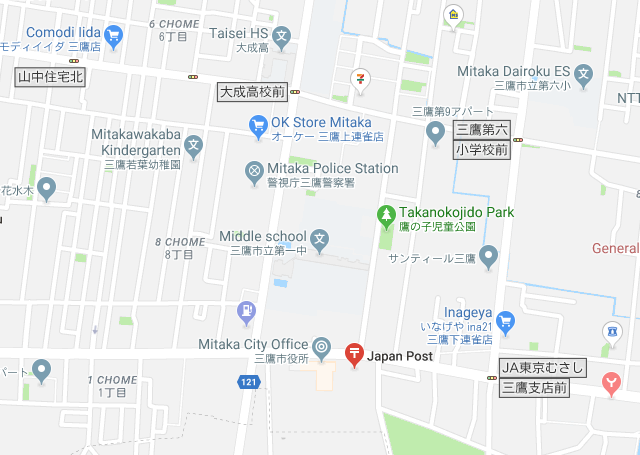
For example, here’s a screenshot from Google Maps showing a part of Mitaka Ward in Tokyo:
▼ You can see the 〒 symbol for the post office, the 文 symbol for schools, the ◎ symbol
for the city office, and the Y-like symbol in the bottom right for the fire station.
Of course the details of the symbols go much deeper than that. There are dozens and dozens of symbols for different types of buildings and areas.
▼ Here’s a small sampling of just 24 common ones.
(Translation below)
13年ぶりに新しい地図記号が追加! お前らこれ何を表す記号か、わかる? https://t.co/1wkeq2uvqR pic.twitter.com/cAkazBURuc
— Almz presents trend (@AlmzTrend) March 16, 2019
Top row: (1) City hall, (2) Town/village hall, (3) Gov. office, (4) Elementary/middle school, (5) High school, (6) Post office, (7) Court, (8) Fire station
Middle row: (1) Hospital, (2) Buddhist temple, (3) Shrine, (4) Power plant, (5) Factory, (6) Police, (7) Three-way intersection, (8) Benchmark
Bottom row: (1) Mulberry field, (2) Wasteland, (3) Broad-leaf forest, (4) Coniferous forest, (5) Rice field, (6) Cultivated land, (7) Orchard, (8) Tea field
With just a quick glance at those symbols, one of them may jump out at you: the symbol for Buddhist temples, the manji. It has an unfortunate resemblance to the swastika, something that has been controversial in the past and whose change has been advocated for, but is still in regular use.
Despite already having a ton of map symbols, Japan has been adding a steady stream of new ones over the past decades, though it seemed as though they’d finally hit a stopping point.
The last two new symbols were added in 2006, thirteen years ago.
▼ They were the symbol for windmill, which is kind of cool…
— 地図記号BOT (@Mapsymbol) March 15, 2019
▼ …and the symbol for retirement home, which is not only hilarious with its
cane inside a house, but it being symbolic of modern Japan too.
老人ホーム pic.twitter.com/jVuHjldFbm
— 地図記号BOT (@Mapsymbol) March 15, 2019
But on the 15th of this month, the Japanese Geographical Survey Institute announced that they would be adding a new symbol to maps.
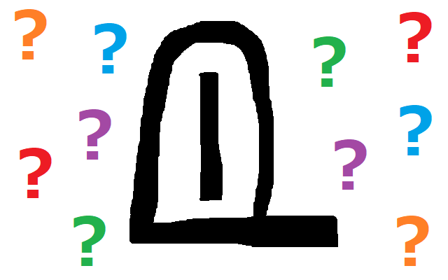
Here’s a glimpse of what the symbol looks like. Can you guess what what it means?
▼ Scroll down for some hints and then the answer!
https://twitter.com/reisikirem/status/1106706879672020992
.
.
.
.
.
.
.
.
.
.
▼ Hint #1: It’s not a symbol for portals to other dimensions, sorry.
.
.
.
.
.
.
.
.
.
.
▼ Hint #2: It’s marking a single, usually somewhat small, thing.
Not a building or an area.
.
.
.
.
.
.
.
.
.
.
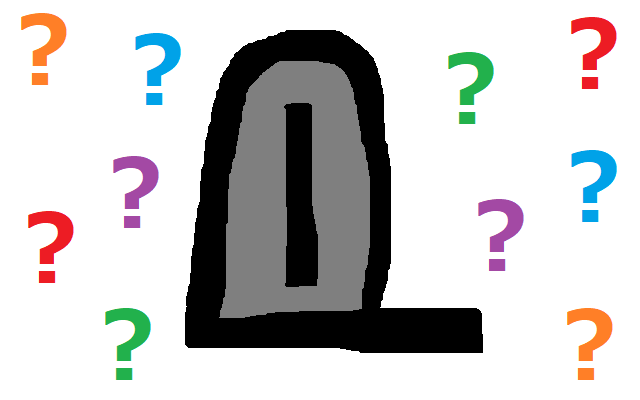
▼ Final hint: It may look a little something like this.

.
.
.
.
.
.
.
.
.
.
▼ Answer: It’s a symbol to mark memorial stones honoring victims of natural disasters.
花見川(千葉市)沿いにある「水難之碑」。結構あちこちにあるけど自然災害伝承碑じゃないのが多いんだ。工事で亡くなった方の慰霊碑。謂れ因縁わからない碑が結構おおいよのね。#地図記号 #自然災害伝承碑 pic.twitter.com/4dbPq5SKtH
— 🐈ひろこば🐈히로코바 (@horse_sheep) March 15, 2019
Did you guess right? Were you even close? No worries if you weren’t. Here’s what Japanese netizens guessed when they first saw the symbol:
“Metal detector.”
“A mail box.”
“Vending machines.”
“I figured maybe a charge spot for electric cars. I was wrong.”
“I thought it was for a public restroom… but we already have a symbol for that.”
“Is it for monoliths?”
That last guess isn’t bad, but the rest make my personal guess of “hot potato vendor” sound reasonable.
▼ Some also pointed out that the symbol bears a striking resemblance to Game Freak’s logo.
新しい地図記号ゲームフリークで草 pic.twitter.com/fggQQixR9c
— MaRiz🥕🐹🦄 (@SSR_MaRi_ow) March 16, 2019
After the huge floods in western Japan last year, there were more stone memorials to the victims put up than in the past hundred years, and the Japanese Geographical Survey Institute wanted their locations to be more known. The symbol for the memorials will start going up online starting June this year, and in print maps starting in September.
Marking the memorials on maps is a nice gesture to the municipalities that put them up. Now if we could just get them to add in a symbol for memorials to otaku-penguins….
Source: Nikkei via My Game News Flash
Images: SoraNews24
● Want to hear about SoraNews24’s latest articles as soon as they’re published? Follow us on Facebook and Twitter!
 【Brain Teaser Time】 Can You Guess What These Cute Little Guys Are Used For?
 What day of the year has the most anime character birthdays? This heat map has the answer
 Japanese convenience store releases Japanese convenience store-flavor fried chicken
 Cup Noodle releases cold-water instant ramen in Japan, but can it really be made with just cold water?
 Hatsune Miku collaborates with Hokusai’s art in new Vocaloid ukiyo-e illustration series [Pics]
 Japan’s “edible fireworks” wagashi sweets return, but only for a limited time [Photos]
 Studio Ghibli releases anime T-shirts that pay homage to one of Hayao Miyazaki’s most personal films
 Japan now has human refrigerators inspired by Japanese vending machines
 Giant Snorlax, other snoozing Pokémon appear in Yokohama for Pokémon Sleeping Faces Research [Pics]
 Japan’s popular curry chain Cocoichi has an elusive delivery-only noodle menu
 Family Mart’s new Tokyo flagship convenience store doesn’t feel convenient, but is that a problem?
 Mos Burger opens Mosh Burger & Bar in Ginza, but is it fated to be a short-lived sensation?
 Cup Noodle unveils first-ever cold-water instant ramen in Japan
 Starbucks Japan releases new Discovery Series collection celebrating local regions and traditions
 Teen girl in Japan refuses to be victim, personally escorts train pervert to police for arrest
 Japanese government ID card and app to be required for certain Pokémon card purchases next month
 Is Japan’s tourism boom slowing down? Foreign visitor numbers fall for first time in five years
 Japan announces sudden 400-percent increase in visa fees for foreigners entering the country
 Studio Ghibli has a new anime out, and there’s only one place in the world where you can see it
 Salomon releases Japan-exclusive Mt. Fuji hiking gear that doubles as an amazing souvenir
 Japanese ninja certification exam attracts 131 candidates from Japan and abroad
 Japan triples departure tax, foreign tourists and locals now must pay more to leave country
 Family Mart opens new “Famima” flagship store in Tokyo that’s like a tourist attraction
 Japan’s human washing machines will go on sale to general public, demos to be held in Tokyo
 Starbucks Japan releases new drinkware and goods for Valentine’s Day
 Starbucks Japan releases new sakura goods and drinkware for cherry blossom season 2026
 Japan’s newest Shinkansen has no seats…or passengers [Video]
 Put sesame oil in your coffee? Japanese maker says it’s the best way to start your day【Taste test】
 Japan reportedly adding Japanese language skill requirement to most common foreigner work visa