
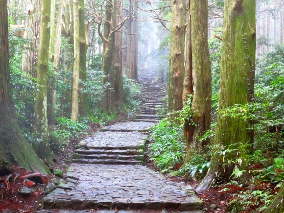
Walking through Japan can be a truly uplifting experience. You see so much more by walking through places, especially sacred places. It’s different from walking to them, seeing, and then leaving. Another bonus is (unless you’re climbing Mount Fuji), there are no crowds since, in our modern world, it just doesn’t occur to most people to see things on foot. As we learned previously, quite a few of Japan’s World Heritage Sites are on hiking trails, and the World Heritage Sites of the Kii Peninsula are also located conveniently along ancient pilgrimage routes of the past.
The Kumano Kodo (actually a network of trails) has been traveled by Japanese worshipers for over 1,000 years. By following the route, you not only get to see ancient Japan, but you’ll encounter nature worship everywhere you turn. You’ll feel more like you’re experiencing ancient Japan, rather than just looking at it from the outside.
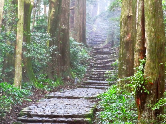
Come with us now as we hike our way along the Nakahechi route, the well-groomed, often cobble-stoned path that connects a string of quaint little towns where you can book into comfortable ryokans serving gourmet food and offering hot spring baths to soothe your tired muscles. This is glamping—Japanese style!
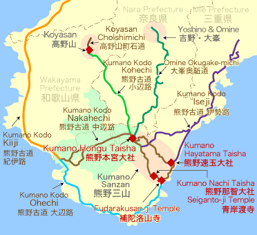
The Kumano Kodo traverses the Kii Peninsula, with the goal being the Kumano Sanzan, the Three Grand Shrines of Kumano. Also referred to as the Kumano Sankei Michi, the route traverses through the “World Heritage Sites of the Kii Peninsula,” and includes Mount Koya, Kumano, and Yoshino and Omine.
 Wakayama World Heritage Center
Most people start their trip at JR Kii Tanabe station on the Wakayama train line out of Osaka (5,270 yen or US$44). If you don’t have a Japan Rail Pass, however, it’ll be cheaper to take the express bus from Osaka to Kiitanabe Station (2,880 yen or US$24). Just outside the train station is the Tanabe City Kumano Tourism Bureau, where everyone speaks English. They’ll help you get on your way whether you’re walking or taking motored transport. They’ll also help with estimated walking times (or bus schedules), and booking accommodations through their community reservation system, but be aware that you have to submit your booking requests two weeks in advance. Accommodations fill up quickly and you’d hate to arrive somewhere only to be turned away by every place in town (been there, done that!). If you’re okay with camping, the tourist bureau will also help you find your way to the designated campgrounds.
The route we took was the recommended four-day route to Hongu Taisha Grand Shrine. From Hongu, the path splits, one branch going to Shingu Hayatama Grand Shrine (a two-day hike), and the other going to Nachi Taisha Grand Shrine (also a two-day hike). We took the route to Shingu, and then hopped on a train to Nachi. The only way to walk to all three shrines is by backtracking back to near Hongu, and taking the other branch.
Day 1: Takijiri to Takahara (2-hr. hike)
Since it takes 4-5 hours by bus or train to get to Kiitanabe from Osaka, the morning of the first day was already gone by the time we started, so we did a short two-day hike from Takijiri to Takahara.
▼ You’ll see oji shrines along the path, such as this one, which in the past served as resting spots for those who made this long pilgrimage to visit the Three Grand Shrines.
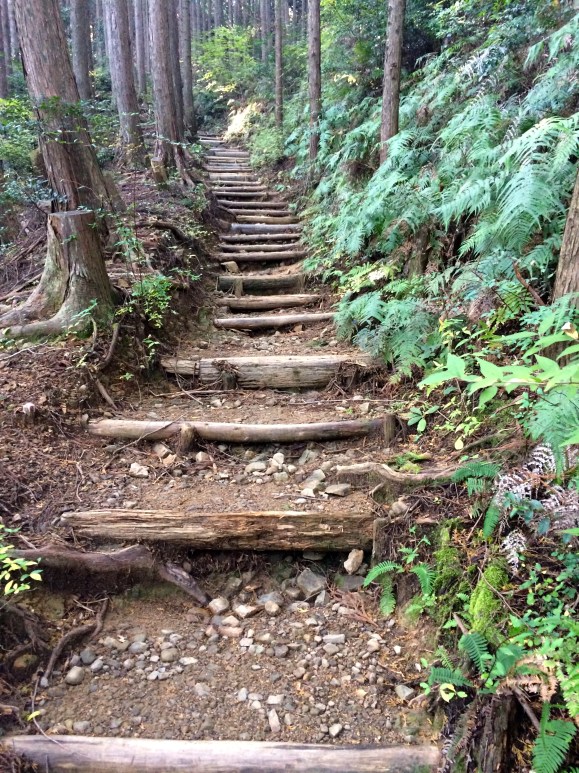
Day 2: Takhara to Chikatsuyu (4-hour hike)
The Kii Peninsula gets 3,000 mm of rainfall every year (118 inches), making it one of the wettest places in Japan.
▼ Plan for the Moss Factor: wear good footwear so you don’t slip!

▼ A ryokan at Chikatsuyu along the river.

Day 3: Chikatsuyu to Hongu (8-9 hour hike)
If you’re more interested in seeing the World Heritage Sites by bus, you can start your journey here at Hongu city, the site of the Kumano Hongu Taisha Grand Shrine.
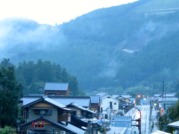
▼ Dawn appears over Hongu city.
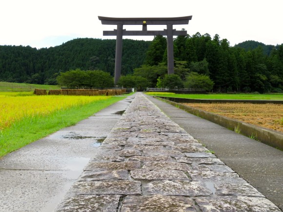
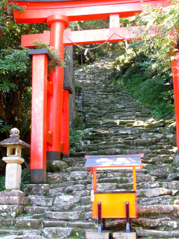
▼ Torii gate to the previous entrance of Kumano Hongu Taisha Grand Shrine. The shrine was relocated to higher grounds due to flooding in 1889.
▼ The current Hongu Taisha Shrine
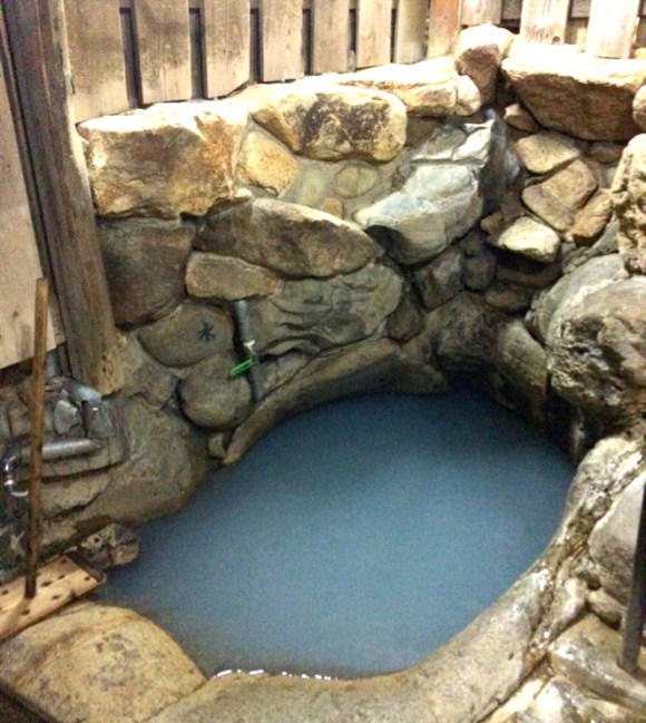
We chose to stay the night in Yunomine, an onsen town, which was a short bus ride off the path. There we bathed in an onsen called Tsuboyu, which was used by Heian pilgrims for purification rites. Tsuboyu is the only UNESCO-listed hot spring open to the public.
▼ Tsuboyu Onsen is built over a river and only accepts two people at a time.
Day 4: Hongu to Koguchi (6-hour hike)
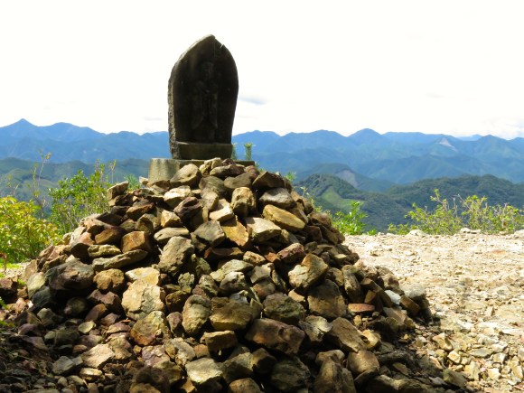
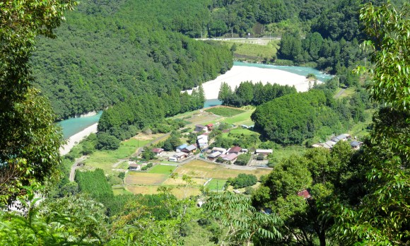
Along this part of the route, the most famous point is Hyakkengura Lookout, where you can gaze out over “the 3,000 peaks of Kumano,” a figurative term to describe the numerous sacred mountains.
▼ Jizo, the deity of travelers and children, holds a special place at Hyakkengura.
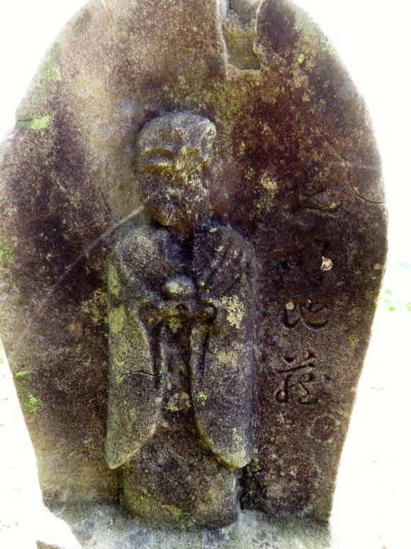
▼ Jizo at hyakkengura look-out is one of the most oft-photographed spots on this part of the Kumano Kodo.
▼ Descending from the trail into the tiny town of Koguchi.
Day 5: Koguchi to Shingu (6-hour hike)
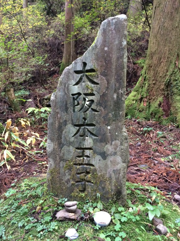
▼ You’ll find these markers all along the Kumano Kodo.

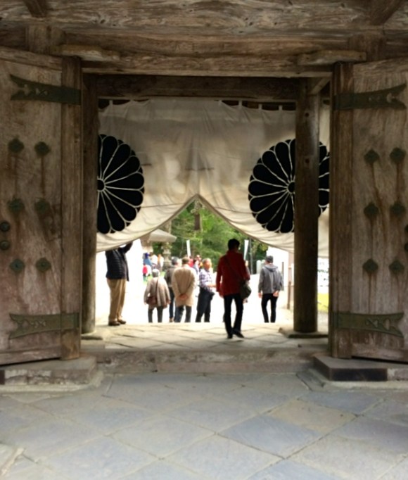
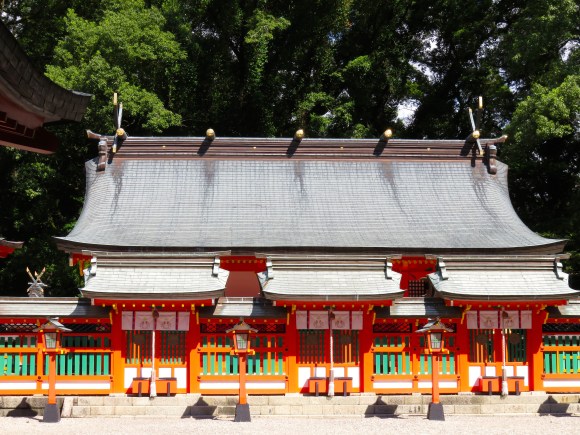
▼ Suzumon at Hayatama Taisha Grand Shrine in Shingu
The three-legged crow, or yatagarasu, is a symbol of Kumano. Ancient belief holds that these crows are divine messengers.
▼ The yatagarasu can be seen emblazoned on various flags and souvenirs related to Kumano.
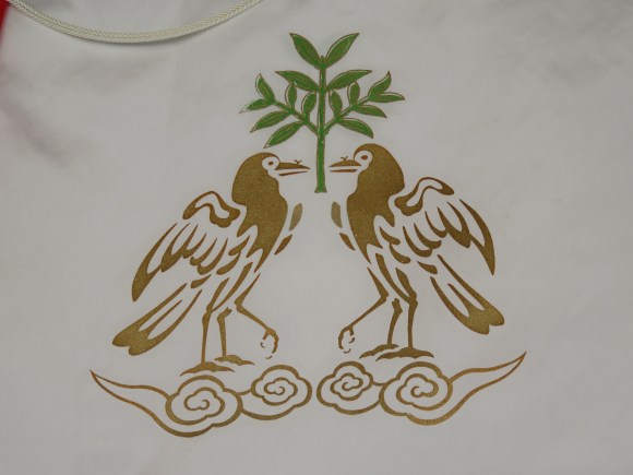
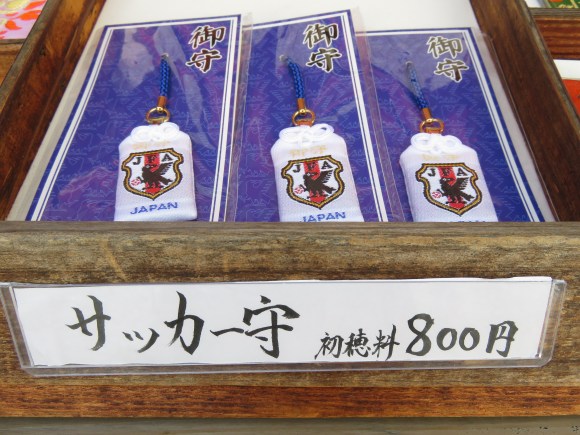
If you think you’ve seen these crows before, you’re right! They’ve also been adopted as the symbol of Japan’s national soccer team—the Samurai Blue.
▼ You can buy soccer amulets at the shrine.
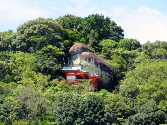
Another important shrine you’ll want to see while you’re in Shingu is Kamikura Jinja, the birthplace of the Kumano religion and which predates the Hayatama Taisha Grand Shrine.
▼ Can you see the shrine? Keep looking! After you see it, you can’t unsee it.
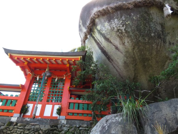
Kamikura Jinja is at the site of a sacred rock where the three Kumano kami, or gods, originally descended. Now, would these kami descend into a parking lot? Of course not! Look up, to the left and you should see something stuck up there in the side of the mountain.
▼ Got your binoculars? Ah yes, there it is—Kamikura Jinja and the sacred rock.
Now, let’s go up there.
▼ The entrance up to Kamikura Jinja. The steps are even steeper than they look!
Actually, climbing up isn’t nearly as bad as coming back down, in which you’ll have to side-step down the stairway because it’s so perilous.
About 15 minutes of ascent brings you to Kamikura Jinja, considered one of Japan’s top power spots, and the origin of the Kumano faith. You’ll have a nice view of the city below too.
▼ Gotobiki, Kamikura Jinja
It’s no wonder they eventually decided to move the kami to a more accessible location—the Kumano Hayatama Grand Shrine, where people can greet them at Shingu, the city whose name means ‘new shrine.'”
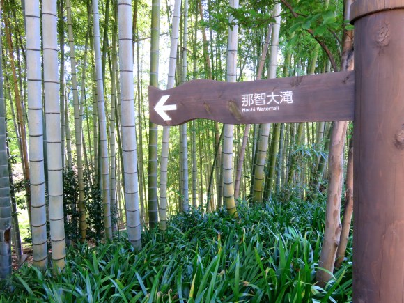
Day 6: Shingu to Nachi Falls
From Shingu, we hopped on a train to Nachi, then a bus from the station to Nachi Taisha Grand Shrine and Nachi Falls.
▼ Daimon zaka.
 Tanabe City Kumano Tourism Bureau
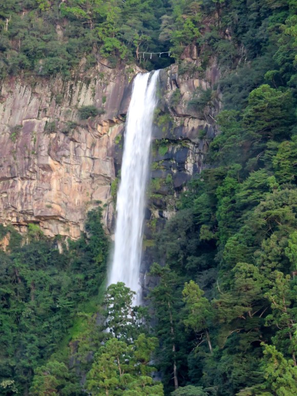
We stayed overnight in the tiny town featuring several ryokan from which you can see Nachi Falls in the distance.
▼ Nachi Waterfall, with a drop of 133 meters (436 ft), is Japan’s tallest single-drop waterfall, and is an object of worship.
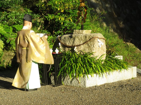
▼ At the bottom of the falls, you’ll find ritual nature worship in real-time.
The Nachi Taisha Grand Shrine also includes the pagoda you often see in photos of Nachi Falls.
▼ Seiganto-ji Pagoda, in the same complex as Nachi Taisha Shrine, is strategically placed to view the falls.

There are many different ways to do the Kumano Kodo pilgrimage route, so you may want to do a bit of exploring yourself to find out which is most suitable for you. On the Nakahechi, there is almost always a bail-out option where you can get on a bus to your destination if it starts raining (or typhooning, as it sometimes does) and as long as you make reservations in advance, you’ll always have a nice dry ryokan waiting with good local food and a hot bath.
There’s even another alternative to driving, taking the bus or train, or walking the pilgrimage. We didn’t actually hike it ourselves, actually. We ran it. But that’s another story…
If you can’t be bothered researching and navigating the route yourself and don’t mind admitting it, sign up for a tour with Oku Japan or Walk Japan.
Featured image: Tanabe City Kumano Tourism Bureau
All photos © Amy Chavez/RocketNews24 unless otherwise noted.
 Here are all of the reasons why you should go to Kumano, Mie Prefecture, for summer sightseeing
 Japan’s top 3 rock “power spots”
 How many have you seen? 18 must-visit sites in Japan 【World Heritage】
 Hatsune Miku collaborates with Hokusai’s art in new Vocaloid ukiyo-e illustration series [Pics]
 Japan now has human refrigerators inspired by Japanese vending machines
 Studio Ghibli releases anime T-shirts that pay homage to one of Hayao Miyazaki’s most personal films
 Starbucks Japan releases new Discovery Series collection celebrating local regions and traditions
 Teen girl in Japan refuses to be victim, personally escorts train pervert to police for arrest
 Family Mart’s new Tokyo flagship convenience store doesn’t feel convenient, but is that a problem?
 Is Japan’s tourism boom slowing down? Foreign visitor numbers fall for first time in five years
 Evangelion beautifully reimagined as iconic classical Japanese folding screen art series [Photos]
 Cup Noodle unveils first-ever cold-water instant ramen in Japan
 Mass murder plot stopped by friend of Akihabara mass murderer
 Japanese government ID card and app to be required for certain Pokémon card purchases next month
 Uniqlo looks back to the very start of Pokémon with new black-and-white pixel art T-shirts[Pics]
 Studio Ghibli has a new anime out, and there’s only one place in the world where you can see it
 Family Mart opens new “Famima” flagship store in Tokyo that’s like a tourist attraction
 Japan announces sudden 400-percent increase in visa fees for foreigners entering the country
 Japanese ninja certification exam attracts 131 candidates from Japan and abroad
 Salomon releases Japan-exclusive Mt. Fuji hiking gear that doubles as an amazing souvenir
 Japan triples departure tax, foreign tourists and locals now must pay more to leave country
 Studio Ghibli store Donguri Republic announces opening of first-ever store in America
 Japanese sweets shop sells an ohagi so exquisite it sells out by noon
 Japan’s human washing machines will go on sale to general public, demos to be held in Tokyo
 Starbucks Japan releases new drinkware and goods for Valentine’s Day
 Starbucks Japan releases new sakura goods and drinkware for cherry blossom season 2026
 Japan’s newest Shinkansen has no seats…or passengers [Video]
 Put sesame oil in your coffee? Japanese maker says it’s the best way to start your day【Taste test】
 Japan reportedly adding Japanese language skill requirement to most common foreigner work visa