
Japan’s major cities offer just about everything, but did you know that includes great nature trails? From forests and waterfalls to ancient temples and shrines, many of Japan’s best hiking trails are literally just a step off the bullet train. If you have a Japan Rail Pass, you’ll find it even harder to resist these hikes near Tokyo, Kyoto, Osaka, Kobe, Hiroshima and Fukuoka. Got a day–or even a half-day–to spare? You can still get your hike in!
These hiking routes make it convenient to explore Japan’s natural surroundings. No long drives to get out to the countryside, no great changes in altitude, and there’s always a good view waiting at the top. The trails are sign-posted, well-maintained, and many pass through historic districts and are tailored for sight-seeing by foot. You’ll find eating establishments, public toilets, lockers and even hot springs along the way on some of them. In short, Japan is a day-hikers dream! And if you like to run, these hiking courses make great running trails too.
You’ll want to be prepared to hike up a bit of vertical on these trails, but we’re guessing that a few inclines aren’t going to hold you back!
1. Kobe–Nunobiki Falls 布引の滝
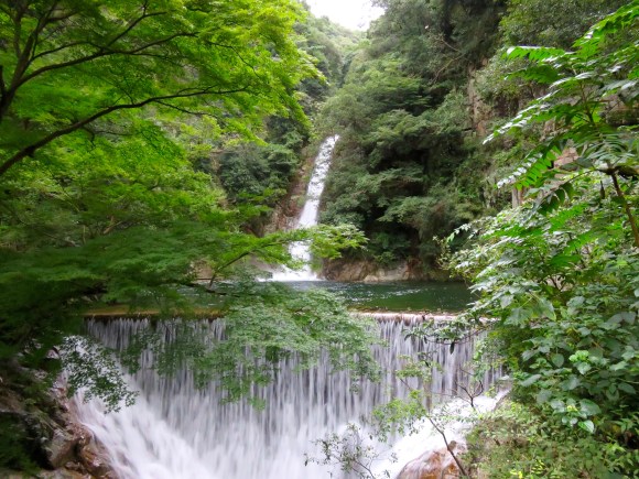
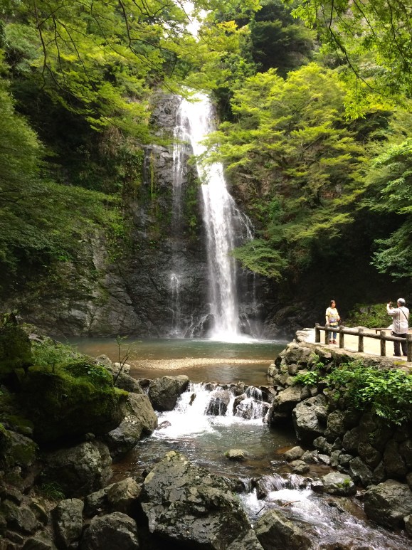
We start off with the dream hike–just out the North entrance of Shin-Kobe Station, this one is so convenient, you’d be lazy not to do it. Thanks to Japan’s abundant rainfall and lush mountains, you’ll find waterfalls almost everywhere you go. The Nunobiki Waterfall hike offers three falls along the way. I get off the Shinkansen here just to do this hike, then I get back on and continue my journey. It’s just too good to pass up.
It turns out that this is a favorite run of the Kobe Hash House Harriers too, according to veteran hasher “Speedy Peety.” There is a sign at the bottom of the course and you’ll pass a series of waterfalls before you get to the top of the hill.
▼ The Nunobiki Falls trail is all paved, in some way or another, and is all uphill.
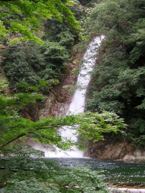
At the top of the trail is the “Herb Garden.” If you are lazy, and are fine with that, you can take the ropeway to the top and walk back down via the falls. Herb Garden hours are 10:00 a.m. to 5:00 p.m (but the last gondola ride is at 4:30).
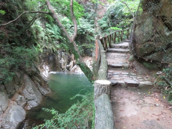
If you want to hike further, pass the herb garden gates (on your right) and just down on the left is a small trail that will take you around the Nunobiki Reservoir and back down a path that eventually hooks up with the original trail. At the bottom of the Nunobiki Falls Trail there is another option to walk to the Kitano tourist district. It’s a short 1.1 km (half-mile or so) walk through the forest and a much more interesting way to get to Kitano than taking the train! Reward yourself at the unique Starbucks there.
You’ll find a map of the Nunobiki Falls course here
Tip: The entrance to the trail is underneath the station, through an underpass that looks like it definitely doesn’t lead to a hiking course.
2. Kyoto–The Kyoto Trail 京都一周トレイル
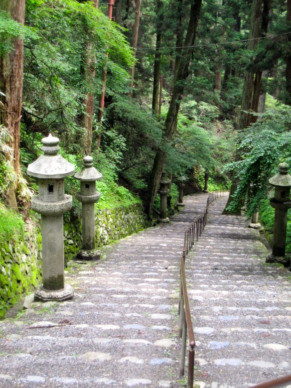
▼ The Kyoto Trail starts at Fushimi Inari
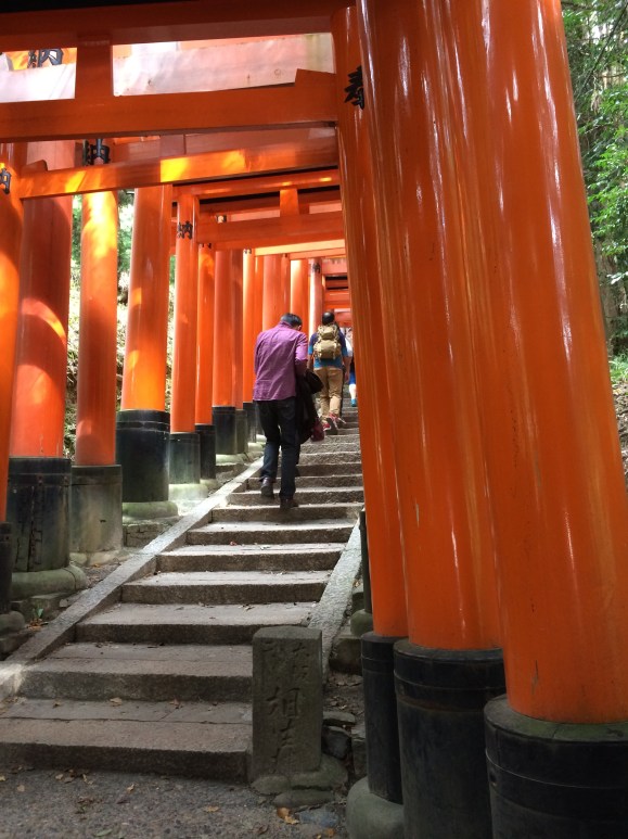
This trail is another dream trail as it passes over bridges and gorges, through historic towns and bamboo forests, past roadside deities, pagodas and waterfalls. You’ll be able to visit shrines and temples, including some of Kyoto’s major tourist sites such as Fushimi Inari Taisha Shrine, Kiomizu-dera Temple, and the Enrakuji Temple Complex (the latter being two of Japan’s 18 UNESCO World Heritage Sites). If you’re a tourist, you’re probably already headed there anyway, so why not take the scenic route?
▼ The signs to the trail can be hard to find, especially with crowds of tourists standing in front of them. Even if you do locate them, they’re likely to be in Japanese until you get onto the trail, which is English-friendly.
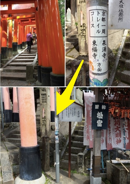
▼ Continue up through the torii gates, through a small graveyard, and look for the unassuming red gates, the only indication there is a trail. After that, you’ll begin to see sign posts which are very clear. From then on, you’ll never be wayward on the trail again–there will always be a signpost nearby.
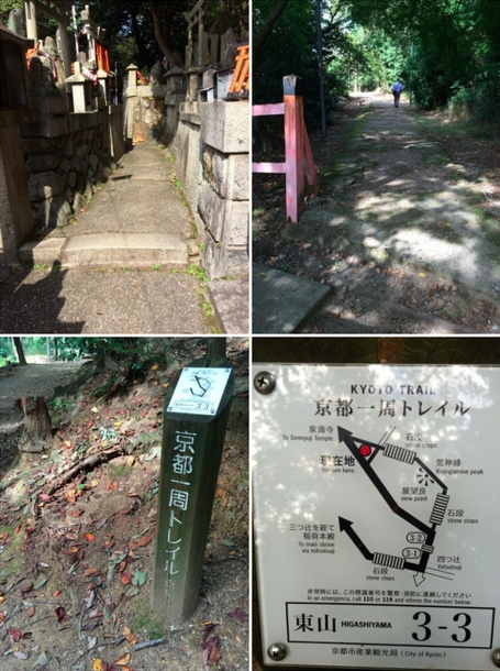
The Kyoto Trail is about 110 kilometers (68 miles) long and encircles the city of Kyoto. You can enter the trail at any point from the city below. Along the path, you can drop down to any number of train stations along the foothills to get back to Kyoto Station or to your hotel.
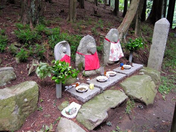
▼ Little stone deities will help you along the way.
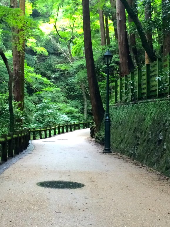
▼ This part of the trail through Mt. Hiezan alternates between dirt and paved paths.
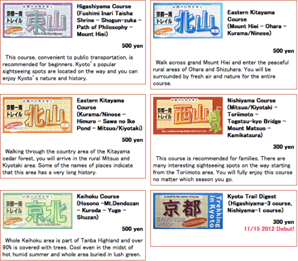
Tip: The tourist information office at Kyoto Station sells maps of the Kyoto Trail for 300 to 500 yen each (US$2.50 to $4). These detailed maps divide the two sections of the trail further down into five bilingual maps: Higashiyama (東山), Kitayama West (北山西部), Kitayama East , (北山東部), Nishiyama 西山, and Keihoku (京北). There is also the Kyoto Trail Digest, a less detailed map of the entire route.
3. Nagano–Karuizawa Kyu Usui Pass 軽井沢
Karuizawa, a beautiful rural town and summer resort community outside Tokyo on the Hokuriku Shinkansen line, offers a plethora of walking, hiking, and cycling routes right out the gates of Karuizawa Station.
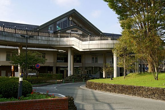
▼ The North Exit of Karuizawa Station
One of our favorites is the Kyu Usui Pass Sightseeing Trail, an 8-kilometer (5-mile) route that follows part of the ancient Nakasendo Trail, one of the five mountain walking routes that connected the capital of Edo (Tokyo) to the outlying provinces during the Edo Period (1603 – 1868).
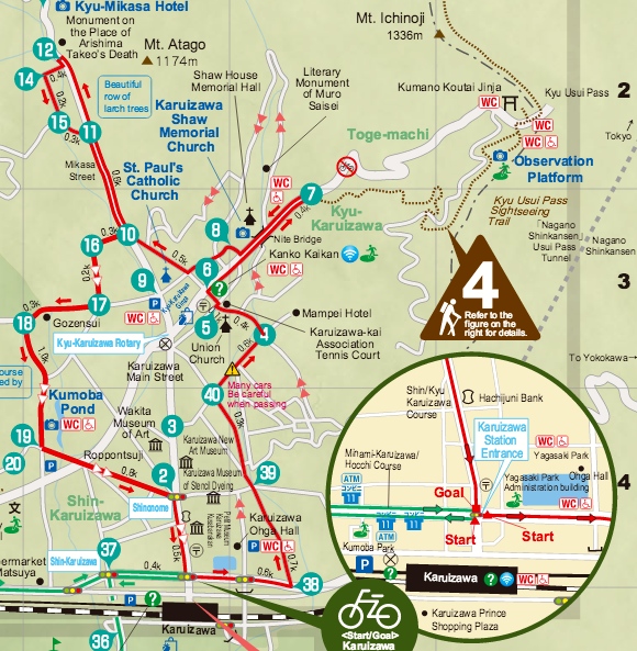
The Kyu Usui Pass Sightseeing Trail, number 4 on the map is about a 20-minute walk from the station.
 (Japan National Tourism Organization)
From the North side of Karuizawa Station, walk straight out the station until you get to the Kyu Kuruizawa Rotary intersection. Turn right towards the post office and you’re on your way to the trailhead. You’ll pass a public restroom and an information booth. Cross a bridge and you’ll be at the trailhead. The route also passes near Kumano Kotei Jinja shrine. There is an observation platform at 1,205 meters (almost 4,000 feet), a popular place to watch the sunset that also offers views of Mount Yatsugatake and Mount Myogi.
Download the complete map as well as other helpful information from the Japan National Tourism Organization.
Tip: Try the Kose Onsen hot spring after a day on the trail.
4. Hiroshima Peace Pagoda and Mount Futaba 二葉山
Our friends over at Get Hiroshima, who are avid hikers and trail runners, introduce a trail that leaves right from the Hiroshima Shinkansen station. Head to the trail that goes up to the Peace Pagoda on Mount Futaba (139 meters/456 feet), just a few hundred meters from the north side of the station. This trail takes you through primordial forest, a tunnel of torii gates and rewards you with great views over the city and the picturesque Seto Inland Sea.
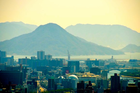
▼ The city of Hiroshima as seen from Mount Futaba, with the Seto Inland Sea in the background.
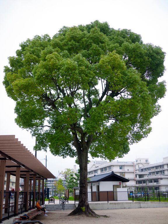
▼ You hike past this camphor tree that survived the A-bomb blast despite being just 2 kilometers (1.2 miles) from the hypocenter.
Tip: Hiroshima is celebrating 70 years of peace and recovery after the Atomic Bomb. They are asking people to join in remembering Hiroshima’s history, celebrating its recovery and enjoying the great city it has become by tagging their photos and posts with #Hiroshima70. What a great way to get involved and promote world peace! Find out more about the digital stamp rally.
5. Osaka–Minou Koen 箕面公演
Okay, this isn’t exactly right off the Shinkansen line, but hey, it’s Osaka, with a population of 19 million people who are known for “kuiadore,” it’s not surprising that you’ll need to hop on a train to get beyond all the restaurants and into some real nature.
I was initially put off by the 25-minute train ride from Shin-Osaka station, which includes one line transfer, but after actually doing it I can assure you it’s a cinch. The country railroad stations are easy to navigate and are well sign-posted. The end of the Takarazuka Line drops you off at Minou Koen, part of a quasi national park.
▼ This short course is all gradual uphill but paved.
At Minou Station there is a tourist office but you don’t really need it. Just head up the street perpendicular to the station, and 2.7 kilometers (about a mile and a half) later, you’ll be at the waterfall. There and back is just over 5 kilometers, so if that’s a bit too short head up further beyond the waterfall to the Tokai Nature Trail, which extends 1,697 kilometers (1,054 miles) all the way to Tokyo! For that, however, you’ll want a map which is available at the tourist office next to Minou Station for 300 yen.
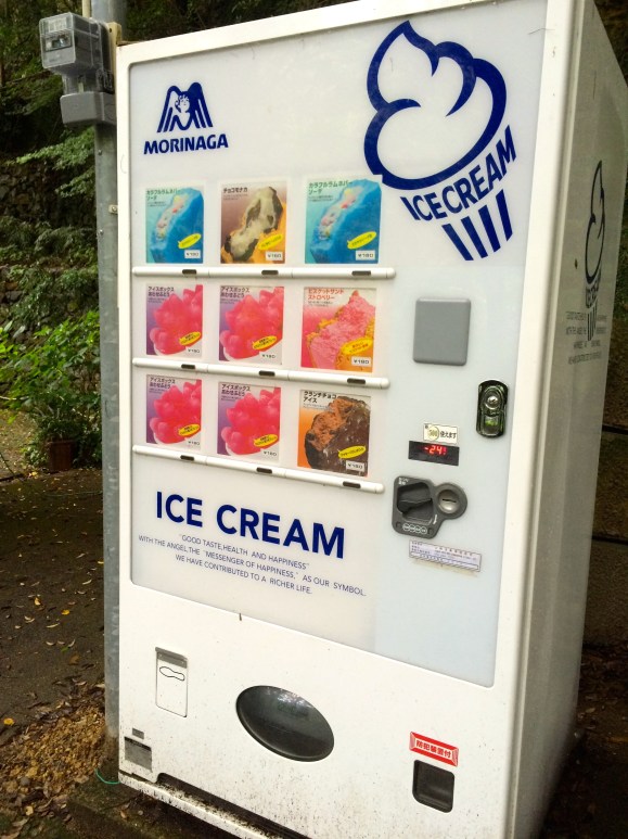
▼ The nice thing about the more touristy routes is the conveniences, such as an ice cream machine (always a welcome sight).
Tip: There’s an insectarium along the route to the waterfall, just in case you haven’t met enough insects outside already.
Bonus Trail!
6. Fukuoka–Mt. Tachibana 立花山 367 meters (1,204 feet) and Mt. Mikatzuki 三日月山 272 meters (892 feet)
A 36-minute train ride from Hakata Station is the start of the Tachibanayama trail. Nick Szasz, who publishes Fukuoka Now, a website passionate about hiking in Fukuoka, provides detailed information on trails as well as tips on what to take on a hike with you, where water sources are for each hike, and other pertinent information, including photos with arrows to show the way.
After hiking Mount Tachibana you can continue on to the easier hike up Mount Mikazuki.
For more details on the Tachibanayama and Mikazukiyama hikes, click here. More hikes in Fukuoka can be found at Fukuoka Now.
Tip: Fukuoka is known for its original goboten udon (udon noodles with burdock tempura). Be sure to try it!
Good luck and see you out on the trails!
H/T to Bob Poulson at Nanban Rengo, for the information on Karuizawa
All images ©Amy Chavez/RocketNews24 unless otherwise noted
 Mt. Fuji hiking trail reservation system and advance payment details released
 Toll fees officially added to Mt. Fuji hiking trail
 New Mt. Fuji overnight bus takes travelers from downtown Tokyo straight to the most popular hiking trail
 Kyoto hiking – Recreating a Touken Ranbu sword boy expedition in real life【Photos】
 How many have you seen? 18 must-visit sites in Japan 【World Heritage】
 Is Japan’s tourism boom slowing down? Foreign visitor numbers fall for first time in five years
 Evangelion beautifully reimagined as iconic classical Japanese folding screen art series [Photos]
 Cup Noodle unveils first-ever cold-water instant ramen in Japan
 Studio Ghibli releases huge new wooden clip collection featuring 25 anime movies
 Starbucks Japan adds new Frappuccino, Tea, and Chillax Soda to its limited-edition summer menu
 Can instant TKG from Don Quijote really recreate Japan’s beloved raw-egg-on-rice dish?
 Tokyo and Osaka make it into this year’s EIU ranking of the world’s Top Ten Most Liveable Cities
 Tokyo Disneyland and Disney Sea raising ticket prices, free Fast Pass ending next month
 Hatsune Miku collaborates with Hokusai’s art in new Vocaloid ukiyo-e illustration series [Pics]
 Shinkansen trial of moderately air conditioned cars draws mixed reactions from travellers
 Studio Ghibli has a new anime out, and there’s only one place in the world where you can see it
 Family Mart opens new “Famima” flagship store in Tokyo that’s like a tourist attraction
 Uniqlo looks back to the very start of Pokémon with new black-and-white pixel art T-shirts[Pics]
 Japan reacts to Donald Trump’s “Islamic Republic of Japan” remark
 Japanese airport rebrands itself as “Sushi Airport” to attract foreign tourists
 Japanese government ID card and app to be required for certain Pokémon card purchases next month
 Three new starter Pokémon Jets to fly in Japan, first begins carrying passengers this month
 Studio Ghibli theme park’s new dessert is a drinkable version of Hayao Miyazaki’s pilot daydream
 Solid gold Hedorah kaiju from the Godzilla series is now available to pre-order
 Japan announces sudden 400-percent increase in visa fees for foreigners entering the country
 Japanese ninja certification exam attracts 131 candidates from Japan and abroad
 Salomon releases Japan-exclusive Mt. Fuji hiking gear that doubles as an amazing souvenir
 Studio Ghibli store Donguri Republic announces opening of first-ever store in America
 Japan triples departure tax, foreign tourists and locals now must pay more to leave country
 Japanese sweets shop sells an ohagi so exquisite it sells out by noon
 Sanrio Character Poll announces winners, Hello Kitty absent from top 10 in many countries
 Japan’s human washing machines will go on sale to general public, demos to be held in Tokyo
 Starbucks Japan releases new drinkware and goods for Valentine’s Day
 Starbucks Japan releases new sakura goods and drinkware for cherry blossom season 2026
 Japan’s newest Shinkansen has no seats…or passengers [Video]
 Put sesame oil in your coffee? Japanese maker says it’s the best way to start your day【Taste test】
 Japan reportedly adding Japanese language skill requirement to most common foreigner work visa
 Everything you need to know about climbing Japan’s second-highest volcano
 Beautifully off the beaten path in Nara with the Shimo no Negimichi shrine trail【Photos】
 How to order snacks on a Shinkansen bullet train in Japan
 Japan travel on a budget: Top 20 free attractions around the country, compiled by TripAdvisor
 Gift-giving made easy! The most popular omiyage bought in Japan, station by station
 Travel off the beaten path to a secret spot in Japan where bamboo grows wild on an old train line