
“Don’t come to Noto, but please come to Ishikawa.”
On January 1, a powerful earthquake struck the northern coast of Japan’s main island of Honshu. More than 200 people lost their lives and tens of thousands had to evacuate their homes, with the most extensive damage occurring in Ishikawa Prefecture’s Noto Peninsula.
When earthquakes occur in Japan, rural areas like Noto, where buildings are older and less quake-proofed and there’s less infrastructure surplus than in big cities, tend to be the hardest hit. Unfortunately, many rural communities are heavily reliant on tourism to keep their local economies afloat, and strong earthquakes can create a ripple of averse effects as travelers avoid the region entirely because they’re unaware of what areas they can safely travel to without getting in the way of relief operations.
This is the position Ishikawa finds itself in. The prefecture still wants travelers to visit and support local merchants, restaurants, hotels, and cultural attractions, but to avoid areas where extensive recovery projects are still ongoing. With that in mind, the official Ishikawa Twitter account is asking potential visitors to refer to a map created by animator and Twitter user @natoriyuichiro, which the Ishikawa government says is a proper representation of the situation as of its January 17 endorsement.
【全国のみなさまへ】
— 石川県「もっといしかわ」 (@motto_ishikawa) January 17, 2024
「能登には来ないで」「でも石川県には来て」というお願いで混乱された方がいらっしゃると聞きました。
『石川県外の方に分かりやすい画像』が投稿されていましたので、良かったらご覧ください。
出典@natoriyuichiro#能登を諦めない#がんばろう石川 https://t.co/SIdyqpj74M
“We’ve heard some people are confused over our request of ‘Don’t come to Noto, but please come to Ishikawa,’” the tweet begins. “A map that’s easy for people from outside of Ishikawa to understand has been posted, so please refer to it.”
Within the map, the area outlined in red marks Ishikawa Prefecture. Ishikawa can be broadly divided into two parts, the Noto region (能登地方) to the north and the Kaga Region (加賀地方) to the south, with the city of Kanazawa (金沢), the prefectural capital, as effectively the north border of Kaga.
Noto has a higher ratio of narrow mountain roads, the map explains, many of which have been blocked or damaged by the quake, causing extensive traffic jams in the area. For this reason, use of private cars is not recommended, in order to leave as much of the road network’s capacity for residents, relief staff, and essential workers. The map also subdivides Noto into Northern Noto (能登北部) (also called Inner Noto [奥能登]), and Southern Noto (能登南部), shown by the red and orange areas on the map. Out of the two, Northern Noto has been especially affected by the quake, as the epicenter was off the northern tip of the coastline.
On the other hand, things in the Kaga region, shown in bright green, are pretty much as normal, the map says. Almost all shops and restaurants are keeping to their regular business hours, and sightseeing attractions remain open. The Hokuriku Shinkansen, which connects Tokyo and Kanazawa, is running as normal, flights are arriving and departing regularly at regional air hub Komatsu Airport, and roads remain open to motorists.
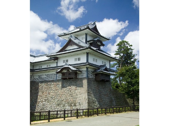
▼ Kanazawa Castle is located in the largely unaffected Kaga regions of Ishikawa.
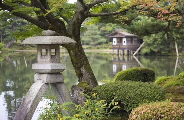
“Please don’t come to Noto yet, but please, definitely, come for sightseeing in Kanazawa and Kaga,” the map’s notes request. They even mention that while Kanazaa is often crowded with tourists, the city is currently light on visitors, so if you’re interested in seeing the city’s historical sites, such as the beautiful Kenrokuen Garden (seen at the top of this article), with smaller crowds while helping the prefecture at a time when tourism revenue is especially critical, now’s your chance.
Source: Twitter/@motto_ishikawa via Hachima Kiko
Top image: Wikipedia/japanexperterna.se
Insert images: Wikipedia/Fg2
● Want to hear about SoraNews24’s latest articles as soon as they’re published? Follow us on Facebook and Twitter!
 Brand-new Pokémon manhole covers coming to help the recovery of a disaster-stricken part of Japan
 Charges dropped against alleged group that broke into vending machine after Noto earthquake
 Watch Ishikawa-set anime, support January 1 earthquake relief efforts
 Pokémon hot spring footbath opening in Japan this spring
 Tokyo subway installing new ticket gates that don’t accept payment through Suica or other IC cards
 Japanese Shinkansen becomes an overnight hotel for three nights this summer
 Face lettuce appears in Japan, with the face of Death Note’s Light Yagami, but why?
 Giant Evangelion Spear of Longinus to be installed at Japanese train station with Eva art trains
 Starbucks Japan releases a miniature display rack so you can create your very own store at home
 Japanese Coo-Che becomes a viral sensation, and everyone wants a taste
 Dance with demons in Kyoto at this Edo-period Japanese Halloween festival
 Why is Taco Bell failing in Japan, even as the country falls in love with tacos?
 99-year-old woman rescued while attempting to climb Mt. Fuji
 New Shinkansen luggage drop-off system begins in Japan, making train travel even easier
 Japan now has human refrigerators inspired by Japanese vending machines
 Studio Ghibli releases anime T-shirts that pay homage to one of Hayao Miyazaki’s most personal films
 Hatsune Miku collaborates with Hokusai’s art in new Vocaloid ukiyo-e illustration series [Pics]
 Japanese convenience store releases Japanese convenience store-flavor fried chicken
 Which country’s foreign tourists spend the most money per-person in Japan? Hint: Not the U..S. or China
 Family Mart’s new Tokyo flagship convenience store doesn’t feel convenient, but is that a problem?
 Studio Ghibli has a new anime out, and there’s only one place in the world where you can see it
 Salomon releases Japan-exclusive Mt. Fuji hiking gear that doubles as an amazing souvenir
 Japan triples departure tax, foreign tourists and locals now must pay more to leave country
 Family Mart opens new “Famima” flagship store in Tokyo that’s like a tourist attraction
 Sanrio Character Poll announces winners, Hello Kitty absent from top 10 in many countries
 Japan announces sudden 400-percent increase in visa fees for foreigners entering the country
 Japan’s human washing machines will go on sale to general public, demos to be held in Tokyo
 Starbucks Japan releases new drinkware and goods for Valentine’s Day
 Starbucks Japan releases new sakura goods and drinkware for cherry blossom season 2026
 Japan’s newest Shinkansen has no seats…or passengers [Video]
 Japanese ninja certification exam attracts 131 candidates from Japan and abroad
 Put sesame oil in your coffee? Japanese maker says it’s the best way to start your day【Taste test】