
Data analysis highlights where hikers are most likely to get a little too far off the beaten path.
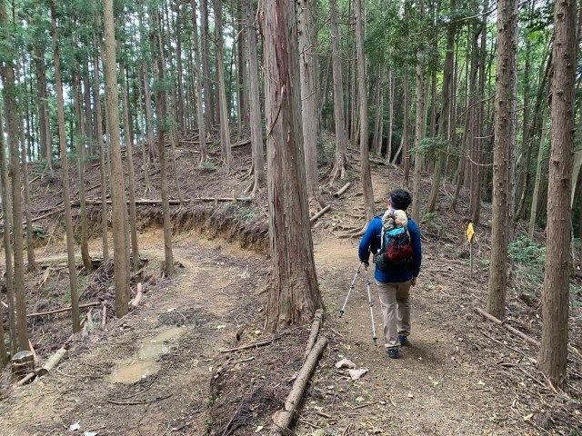
As an island nation, Japan has plenty of beaches that people flock to in the summer, but the country’s mountains are a popular destination for outdoorsy types too. Especially now that we’re out of the rainy season, more and more people are going to be hitting the hiking trails, but there’s one thing to watch out for: some mountains are really, really easy to get lost on.
Japanese hiking app Yamap (a mashup of “yama,” the Japanese word for “mountain,” and “map”) recently finished an analysis of its user submitted data, sifting through which mountain trails had been most marked as easy to get lost on as well as which of those warnings were rated as the most useful by others. From that, they put together a list of the five most confusing, easiest-to-get-lost spots on mountain trails in Japan, so let’s take a look at the results, and maybe take some notes, so that we don’t get lost ourselves.
1. Kakamigahara Alps Gongenyama – Kiriyazaka (Gifu Prefecture)
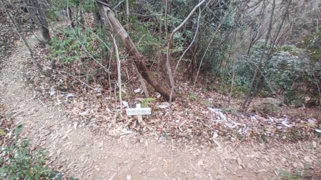
Out of the top five, this spot on the Gongenyama-to-Kiriyazaka route is the only one where you’ll see a sign. That sign looks to be lower than knee-high, though, with only some small, faded lettering letting you know that you need to go right for the walking trail to Kiriyazaka. Head left, and the trail will dead end as the mountain goes vertical for a full-on climbing section.
2. Tenkakusan – Aganonoatama (Saitama Prefecture)
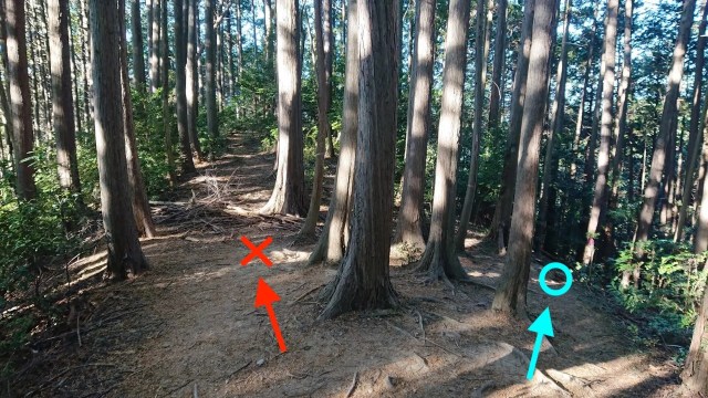
OK, no more signs from here on out! This Saitama trail gets pretty counterintuitive this spot where continuing on the nice flat, broad path to the left leads you to the steep edge of the mountain. Instead, you want to veer right, down that narrow section where your feet will temporarily be at a 45-degree angle. Why no sign here? Apparently the pink tape wrapped around that one tree trunk (just to the right of the blue circle added to the photo) is supposed to be enough to guide you in the right direction.
3. Nenogongen – Mutsuishinoatama (Saitama Prefecture)

Now there’s not even marking tape, but if you want to make it to the end of the trail, you need to hang a left at this seemingly random spot.
4. Gozaishodake – Buheitoge (Shiga and Mie Prefectures)
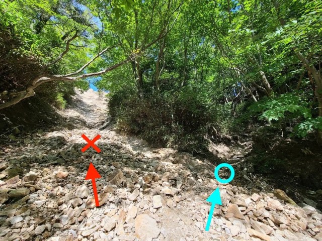
Once again, you pretty much have to go against all your instincts here. The left-side path of least resistance will eventually meet up with the rest of the trail, but it’s a steep, slippery incline that’ not officially part of the route, whereas the easier-to-navigate, but harder-to-notice, path on the left is the one you’re supposed to go on.
5. Takahatayama – Nakanosawanoatama (Saitama Prefecture)
And last, here we’ve at least got two clearly identifiable paths, but no indication as to which one we’re supposed to take. In this case, right is right, as taking the left path will send you off course.
Obviously, part of Yamap’s goal in releasing these rankings is to encourage people to use their app so that they don’t get lost, but they also hope to encourage local forestry services to add clearer trail markings at these points. Yamap put together a similar ranking last year, and says that increased signage resulted in no cases of lost hikers on those trails. For the time being, though, it’s probably a good idea to make sure your phone has a full charge before you hit the trails, not just so that you can take pictures, but so that you can check your location too.
Related: Yamap
Source, images: PR Times
● Want to hear about SoraNews24’s latest articles as soon as they’re published? Follow us on Facebook and Twitter!
[ Read in Japanese ]
 Hiker needs to be rescued from Mt. Fuji twice in five days for very dumb reason
 Climbing season officially opens for Japan’s Mt. Hiyoriyama, the shortest mountain in the country
 Barricades placed on Mt. Fuji as mountain officially closes because of coronavirus【Video】
 Foreign tourist needs ambulance to pick him up at Mt. Fuji after hiking closed trail
 Two Americans decide to hike Mt. Fuji before trails open, both need rescues on back-to-back days
 Air-conditioned dress shirts arrive in Japan to save working professionals from sweltering heat
 Tokyo’s newest viral dessert is like a Japanese parfait inside a bread bun [Taste test]
 Live-action Princess Mononoke is coming to streaming as a live event, previews look amazing [Video]
 Starbucks Japan opens new store inside historic seaside quarantine station near Tokyo
 Tokyo security guard’s famous station tape font becomes official custom Nike streetwear
 Starbucks Japan releases first-ever gacha capsule toys, featuring iconic menu items as plush coffee charms
 Godiva Japan gets into the shaved ice scene with two luxurious frozen desserts this summer
 7-Eleven Japan adds new cold soup smoothies to its convenience store drinks range
 New Studio Ghibli washi tape adds anime flair to Japanese stationery
 Koei Tecmo continues to be an investment firm that also happens to make video games
 Tokyo subway installing new ticket gates that don’t accept payment through Suica or other IC cards
 Japanese Shinkansen becomes an overnight hotel for three nights this summer
 Face lettuce appears in Japan, with the face of Death Note’s Light Yagami, but why?
 Pokémon Card Stores requiring facial recognition scans for entry in Japan in latest anti-scalper move
 Family Mart’s new Famima flagship in Tokyo has a hidden gem that most visitors miss
 7-Eleven Japan now offering baked-in-store pizza by the slice with two very different topping sets
 Starbucks Japan unveils exclusive new Frappuccinos limited to three regional areas
 Giant Evangelion Spear of Longinus to be installed at Japanese train station with Eva art trains
 Studio Ghibli has a new anime out, and there’s only one place in the world where you can see it
 Salomon releases Japan-exclusive Mt. Fuji hiking gear that doubles as an amazing souvenir
 Japan now has human refrigerators inspired by Japanese vending machines
 Hatsune Miku collaborates with Hokusai’s art in new Vocaloid ukiyo-e illustration series [Pics]
 New Shinkansen luggage drop-off system begins in Japan, making train travel even easier
 Japan triples departure tax, foreign tourists and locals now must pay more to leave country
 Studio Ghibli releases anime T-shirts that pay homage to one of Hayao Miyazaki’s most personal films
 Family Mart opens new “Famima” flagship store in Tokyo that’s like a tourist attraction
 Uniqlo looks back to the very start of Pokémon with new black-and-white pixel art T-shirts[Pics]
 Japan announces sudden 400-percent increase in visa fees for foreigners entering the country
 Japan’s human washing machines will go on sale to general public, demos to be held in Tokyo
 Starbucks Japan releases new drinkware and goods for Valentine’s Day
 Starbucks Japan releases new sakura goods and drinkware for cherry blossom season 2026
 Japan’s newest Shinkansen has no seats…or passengers [Video]
 Japanese ninja certification exam attracts 131 candidates from Japan and abroad
 Put sesame oil in your coffee? Japanese maker says it’s the best way to start your day【Taste test】
 Fourth dead body found on Mt. Fuji in less than one week from climbing season start
 Let’s hike a Japanese mountain (that isn’t Mt. Fuji) – Mt. Tsukuba[Photos]
 All Mt. Fuji summit trails are now closed as hiking season ends
 Foreign hiker on Mt. Fuji loses consciousness and dies, becoming climbing season’s second fatality
 Cost to climb Mt. Fuji doubles, some hikers may have to pass test before getting on trail
 British couple in shorts, T-shirt call for rescue from Japanese mountain, say it’s too cold for them to move
 Angry Japanese mayor wants off-season Mt. Fuji hikers to pay costs of their rescue operations
 Mt. Fuji is officially closed for the year
 Mountain meshi hiking! Our guide takes us to the top of Izugatake for an unforgettable lunch【Pics】
 How to climb Mt. Fuji in 2025
 Mt. Fuji climbing reservation website is now open, and here’s how to reserve your spot
 99-year-old woman rescued while attempting to climb Mt. Fuji
 This is Japan’s second-shortest mountain, and we climbed it without realizing it【Photos】
 Three people die on Mt. Fuji less than 24 hours after official start of climbing season