
It seems Google Maps and Google Street View is truly unending in their quest to walk around and take panoramic photos of some of the Earth’s most beautiful locations. So far we’ve witnessed the eerie wonder of Gunkanjima and the spectacular sights of Mt. Fuji’s summit all courtesy of Google. And now we are treated to a place found on many people’s bucket list: Angkor, Cambodia.
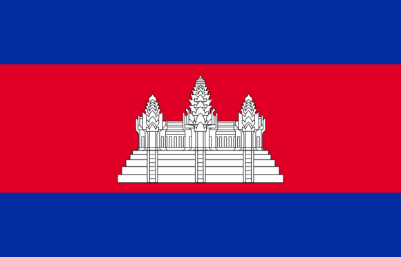
In a six month period Google has sent its Street View cameras in to chronicle over 100 of the area’s historical sites and deliver it straight to you. Naturally Angkor Wat is there for you to tour. The most famous of Angkor’s landmarks, it’s even printed on the Cambodian flag.
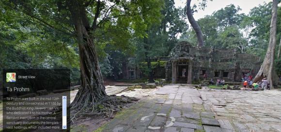
But that’s just the tip of the historical beauty in the region. Just take a stroll through The Banyon and get a close look at the many beautiful reliefs carved through out.
You can even stand atop a pyramid in Koh Ker found in a remote region of Cambodia that’s hard to traverse due to landmines. It appears that didn’t stop the Google crew, nor did it this guy in flip-flops.
And there’s still a whole lot more in this tour using 90,000 images. It could take considerable time to go through click by click, so if your the busy type who wants it quick and dirty, there’s a promotional video and menu of quick links below.
So why not take a moment or several to soak in the rich arts and engineering that has survived over a millennium from what is believed to be the world’s largest pre-industrial city.
Source: Google Asia Pacific Blog (English) via Netlab (Japanese)
Cambodian Flag Image: Wikipedia
Video: YouTube – Google Maps
 Six outdoor Japanese hot springs you can visit right now (with Google Street View)
 Spend a day at the zoo on Google Maps
 Hang in there, Baby!: Cat clinging to wall in Tokyo caught on Google Maps
 Japanese convenience store releases Japanese convenience store-flavor fried chicken
 Cup Noodle releases cold-water instant ramen in Japan, but can it really be made with just cold water?
 Hatsune Miku collaborates with Hokusai’s art in new Vocaloid ukiyo-e illustration series [Pics]
 Studio Ghibli releases anime T-shirts that pay homage to one of Hayao Miyazaki’s most personal films
 Japan’s “edible fireworks” wagashi sweets return, but only for a limited time [Photos]
 Japan now has human refrigerators inspired by Japanese vending machines
 Starbucks Japan unveils new peach milk pudding drink that’s like a decadent dessert
 Giant Snorlax, other snoozing Pokémon appear in Yokohama for Pokémon Sleeping Faces Research [Pics]
 Japan’s popular curry chain Cocoichi has an elusive delivery-only noodle menu
 Family Mart’s new Tokyo flagship convenience store doesn’t feel convenient, but is that a problem?
 Cup Noodle unveils first-ever cold-water instant ramen in Japan
 Starbucks Japan releases new Discovery Series collection celebrating local regions and traditions
 Teen girl in Japan refuses to be victim, personally escorts train pervert to police for arrest
 Japanese government ID card and app to be required for certain Pokémon card purchases next month
 Is Japan’s tourism boom slowing down? Foreign visitor numbers fall for first time in five years
 Japan announces sudden 400-percent increase in visa fees for foreigners entering the country
 Studio Ghibli has a new anime out, and there’s only one place in the world where you can see it
 Salomon releases Japan-exclusive Mt. Fuji hiking gear that doubles as an amazing souvenir
 Japanese ninja certification exam attracts 131 candidates from Japan and abroad
 Japan triples departure tax, foreign tourists and locals now must pay more to leave country
 Family Mart opens new “Famima” flagship store in Tokyo that’s like a tourist attraction
 Japan’s human washing machines will go on sale to general public, demos to be held in Tokyo
 Starbucks Japan releases new drinkware and goods for Valentine’s Day
 Starbucks Japan releases new sakura goods and drinkware for cherry blossom season 2026
 Japan’s newest Shinkansen has no seats…or passengers [Video]
 Put sesame oil in your coffee? Japanese maker says it’s the best way to start your day【Taste test】
 Japan reportedly adding Japanese language skill requirement to most common foreigner work visa
 Hiyoriyama newly crowned as Japan’s Shortest Mountain
 Tokyo woman mugged for 3,000 yen, haggles mugger down to 1,000
 Navigate your way through Japan’s busiest train stations with Google Street View
 Seamen in Hokkaido shocked to discover bright lavender crab
 More and more Japanese moms agree: boys should wear girls’ swimsuits
 Japan’s “Underground Temple” now up for virtual touring in Google Street View
 Extreme budget travel! Can you do a quick trip to Angkor Wat with 50,000 yen (US$334)? – Part 2
 Lettuce farmers of “Miracle Village” looking for love – benefits include cute dogs and a six-figure salary
 We try 400-year-old Ghost Child Care Candy – so good it’ll raise the dead
 Google Street View catches Russian bear in the middle of snacking on a salmon
 Pink-shirted multiplying man found in Akihabara on Google Street View
 Scope out which love hotel to take your next date to right now in Google Street View
 Tour Akita Prefecture from the back of an Akita Inu Dog with Google’s adorable doggie Street View
 Japan dominates the list of most visited Google Street View locations in Asia